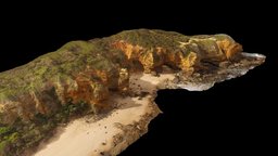
Model's Description:
Split Point, Victoria (Australia) 3D Model, Fully textured with UV Mapping and materials.
Download
Split Point in various files formats such as Wavefront Object format, Autodesk FBX, DirectX 9.0, Stereo Lithography and HTML5 JSON format.
Latitude: -38.468879°, Longitude: 144.103664° See location here. Area shown is about 700 m wide 3D Model is ready to download for free
with 1 Texture files attached, this model contains 346200 polygons and 174076 vertices.
Model's rating is (3) based on 44 Votes.
Model's Description:
River gravel surface 2, Germany 3D Model.
Download River gravel surface 2 in various files formats such as Wavefront Object format, Autodesk FBX, DirectX 9.0, Stereo Lithography and HTML5 JSON format.
Another surface of a bar of river gravel along the Isar river, southern Germany, about 800 m upstream of outcrop https://skfb.ly/6RZFy. Most of the clasts are carbonates, but there are a few other lithologies, including clasts from the Alpine basement. In default view, left is upstream (south) and right is downstream (north). The orange pen is 13 cm long. Lat 47°54‘14.80”N, Lon 11°27‘5.48”E, elevation 578 m 3D Model is ready to download for free, this model contains 599999 polygons.
Model's Description:
Construction dig site excavation hole 3D Model.
Download Construction dig site excavation hole in various files formats such as Wavefront Object format, Autodesk FBX, DirectX 9.0, Stereo Lithography and HTML5 JSON format.
Construction dig site excavation street reconstruction ground earth work, grave hole, heap of clay mud
Raw photogrammetry scan (300x24MP), 2x16K texture - Construction dig site excavation hole - Buy Royalty Free 3D model by matousekfoto 3D Model is ready to download for free, this model contains 621460 polygons.
Model's Description:
Splitting Rivers Landscape 3D Model.
Download Splitting Rivers Landscape in various files formats such as Wavefront Object format, Autodesk FBX, DirectX 9.0, Stereo Lithography and HTML5 JSON format.
Waters traveling in new directions, with Gaea and Substance Painter - Splitting Rivers Landscape - Buy Royalty Free 3D model by taber.noble 3D Model is ready to download for free, this model contains 332928 polygons.
Model's Description:
3D Model.
Download in various files formats such as Wavefront Object format, Autodesk FBX, DirectX 9.0, Stereo Lithography and HTML5 JSON format.
3D Model is ready to download for free, this model contains 700000 polygons.
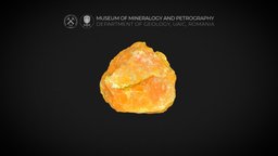
Model's Description:
Peperito 3D Model.
Download Peperito in various files formats such as Wavefront Object format, Autodesk FBX, DirectX 9.0, Stereo Lithography and HTML5 JSON format.
Modelo virtual de afloramento no costão norte da praia da Guarita, Parque Municipal da Guarita em Torres, RS.
No modelo pode ser observada rocha formada pela interação entre lava e areia (Peperito). Formação Serra Geral, Bacia do Paraná 3D Model is ready to download for free, this model contains 1940440 polygons.
Model's Description:
Fontaine Wallace 3D Model.
Download Fontaine Wallace in various files formats such as Wavefront Object format, Autodesk FBX, DirectX 9.0, Stereo Lithography and HTML5 JSON format.
One of the many Wallace fountains in Paris. There are hundreds of them in Paris, and provide drinkable water.
Learn more about Wallace fountains on Wikipedia - Fontaine Wallace - Download Free 3D model by Maurice Svay (@mauricesvay) 3D Model is ready to download for free, this model contains 273760 polygons.
Model's Description:
Arctic Mountains 3D Model.
Download Arctic Mountains in various files formats such as Wavefront Object format, Autodesk FBX, DirectX 9.0, Stereo Lithography and HTML5 JSON format.
Trying out some arctic mountains with Gaea and Substance Painter! Thanks for viewing :-)! - Arctic Mountains - Buy Royalty Free 3D model by taber.noble 3D Model is ready to download for free, this model contains 378110 polygons.
Model's Description:
Brekziierter Ammonit aus dem UNESCO Geopark Ries 3D Model.
Download Brekziierter Ammonit aus dem UNESCO Geopark Ries in various files formats such as Wavefront Object format, Autodesk FBX, DirectX 9.0, Stereo Lithography and HTML5 JSON format.
Das Modell zeigt einen brekziierten Ammoniten aus einer Braunjurascholle der charakteristischen Bunten Brekzie. Durch den Einschlag des Ries-Asteroiden vor ca. 15 mio. Jahren wurde das etwa 170 mio. Jahre alte Meeresfossil zerrüttet und anschließend wieder zusammenzementiert. Die rote Färbung ist auf die Anreicherung von Eisen in den Braunjuraschichten zurückzuführen.
Fundort: Geopark Ries (Hinweis: Im gesamten UNESCO Geopark Ries ist das Sammeln von Fossilen nicht gestattet) - Brekziierter Ammonit aus dem UNESCO Geopark Ries - 3D model by GeoparkRies 3D Model is ready to download for free, this model contains 309050 polygons.
 3D Model")