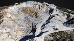
Model's Description:
CANTERA DE ÁRIDOS EN PADÚL (GRANADA) 3D Model, Fully textured with UV Mapping and materials.
Download
CANTERA DE ÁRIDOS EN PADÚL (GRANADA) in various files formats such as Wavefront Object format, Autodesk FBX, DirectX 9.0, Stereo Lithography and HTML5 JSON format.
Cantera de áridos El Chaparral. En ella se extrae fundamentalmente granito gris padules en diferentes granulometrías. [https://ibb.co/JtmmyY2] - CANTERA DE ÁRIDOS EN PADÚL (GRANADA) - Download Free 3D model by Zenit Drones (@zenitdrones) 3D Model is ready to download for free
with 1 Texture files attached, this model contains 200000 polygons and 107164 vertices.
Model's rating is (3) based on 23 Votes.
Model's Description:
Monemvasia town scene 3D Model.
Download Monemvasia town scene in various files formats such as Wavefront Object format, Autodesk FBX, DirectX 9.0, Stereo Lithography and HTML5 JSON format.
*Monemvasia (Greek: Μονεμβασιά, Μονεμβασία, or Μονεμβάσια) is a town and municipality in Laconia, Greece. The town is located on a small island off the east coast of the Peloponnese, surrounded by the Myrtoan Sea. The island is connected to the mainland by a short causeway 200 metres (660 ft) in length. Its area consists mostly of a large plateau some 100 m (330 ft) above sea level, up to 300 m (980 ft) wide and 1 kilometre (0.62 mi) long. Founded in the sixth century, and thus one of the oldest continually-inhabited fortified towns in Europe, the town is the site of a once-powerful medieval fortress, and was at one point one of the most important commercial centres in the Eastern Mediterranean. The town’s walls and many Byzantine churches remain as testaments to the town’s history. * [wiki]
Historical Mediterranean Sea Greece Greek Italian town village countryside scene background
Experimental, reconstructed from various 4K drone footage only - Monemvasia town scene - Download Free 3D model by FUD-UJEP 3D Model is ready to download for free, this model contains 1109375 polygons.
Model's Description:
Massive embankments on the construction site 3D Model.
Download Massive embankments on the construction site in various files formats such as Wavefront Object format, Autodesk FBX, DirectX 9.0, Stereo Lithography and HTML5 JSON format.
Massive embankments on the construction site. The first stage of construction of the production hall.
Model 3D created in RC from 2062 images (dji mini 3 pro)
For Skechfab:
1 mln triangles, 10x8192x8192 jpg + normal
Download version:
FBX Triangles: 15 mln Textures: 10x8192x8192 24-bit jpg + normal
If you like my work leave a like or comment and follow me for more! Thanks :) - Massive embankments on the construction site - Buy Royalty Free 3D model by archiwum_xyz 3D Model is ready to download for free, this model contains 1000009 polygons.
Model's Description:
MH-6 Little Bird Helicopter 3D Model.
Download MH-6 Little Bird Helicopter in various files formats such as Wavefront Object format, Autodesk FBX, DirectX 9.0, Stereo Lithography and HTML5 JSON format.
MH-6 Little Bird Helicopter
Full 3D modeled interior and cockpit
3D modeled indicators and separated objects
Organized workflow and files
Emission maps included
Substance Painter Project included to make your own skins
Fully UV unwrapped
File format: Blend FBX OBJ
Materials/Textures: PBR textures in substance painter
Material Maps: Base color, Roughness, Metallic, Normal, Emission
Texture resolution: 4k textures
Polycount:
Objects: 158
Vertices: 107.945
Edges: 198.885
Faces: 92.633
Triangles: 192.568
- MH-6 Little Bird Helicopter - Buy Royalty Free 3D model by luisbcompany 3D Model is ready to download for free, this model contains 192568 polygons.
Model's Description:
SUBSANACION DISCREPANCIAS CATASTRALES CON DRONES 3D Model.
Download SUBSANACION DISCREPANCIAS CATASTRALES CON DRONES in various files formats such as Wavefront Object format, Autodesk FBX, DirectX 9.0, Stereo Lithography and HTML5 JSON format.
Hoy en día, el uso de los drones se ha convertido en una herramienta fundamental para aquellos propietarios de inmuebles con problemas catastrales.
La fotogrametría aérea con drones, y muy especialmente la generación de ortomosaicos de alta resolución y precisión, permite a los técnicos identificar esas discrepancias de una manera rápida, ágil y justificada.
El propio Catastro hace uso de la cartografía aérea. En la actualidad, con la utilización generalizada de los drones, su uso se ha democratizado.
Este modelo ha sido el resultado de un vuelo fotogramétrico con el objetivo de determinar con precisión los linderos físicos y superficie de una de las parcelas ubicadas en el área de vuelo, y comprobar así su concordancia con el Catastro y el resto de parcelas catastrales colindantes 3D Model is ready to download for free, this model contains 349330 polygons.
![Cantera de áridos El Chaparral. En ella se extrae fundamentalmente granito gris padules en diferentes granulometrías.
[https://ibb.co/JtmmyY2] - CANTERA DE ÁRIDOS EN PADÚL (GRANADA) - Download Free 3D model by Zenit Drones (@zenitdrones) 3d model](3dmodelsr/c5a908f823cd491ea352a334e25f114d.jpg "CANTERA DE ÁRIDOS EN PADÚL (GRANADA) 3D Model")