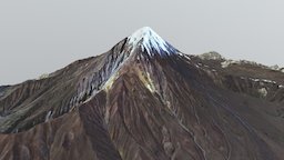
Model's Description:
Mount Damavand (دماوند) Map (1:125,000 Scale) 3D Model, Fully textured with UV Mapping and materials.
Download
Mount Damavand (دماوند) Map (1:125 in various files formats such as Wavefront Object format, Autodesk FBX, DirectX 9.0, Stereo Lithography and HTML5 JSON format.
Order a 6"x6" 3D Print Mount Damavand (Persian: دماوند), a potentially active volcano, is a stratovolcano which is the highest peak in Iran and the Middle East, and the highest volcano in Asia; the Kunlun Volcanic Group in Tibet is higher than Damāvand, but are not considered to be volcanic mountains. Damāvand has a special place in Persian mythology and folklore. It is in the middle of the Alborz range, adjacent to Varārū, Sesang, Gol-e Zard, and Mīānrūd. It is near the southern coast of the Caspian Sea, in Amol County, Mazandaran Province, 66 kilometres (41 miles) northeast of the city of Tehran. Mount Damāvand is the 12th most prominent peak in the world, and the third most prominent in Asia after Mount Everest and Puncak Jaya. It is the highest volcanic mountain in Asia, and part of the Volcanic Seven Summits mountaineering challenge. Source: Wikipedia - Mount Damavand (دماوند) Map (1:125,000 Scale) - 3D model by smartmAPPS 3D Model is ready to download for free
with 2 Texture files attached, this model contains 1661620 polygons and 838406 vertices.
Model's rating is (3) based on 24 Votes.
Model's Description:
Lofoten, Norway Map (1:400,000 Scale) 3D Model, Optimized by RigModels.com, Fully textured with UV Mapping and materials.
Download Lofoten in various files formats such as Wavefront Object format, Autodesk FBX, DirectX 9.0, Stereo Lithography and HTML5 JSON format.
Order a 8.5”x14” 3D Print
Lofoten is an archipelago and a traditional district in the county of Nordland, Norway. Lofoten is known for a distinctive scenery with dramatic mountains and peaks, open sea and sheltered bays, beaches and untouched lands. Though lying within the Arctic Circle, the archipelago experiences one of the world’s largest elevated temperature anomalies relative to its high latitude.
Source: Wikipedia
Data Sources: Norwegian Mapping Authority (Elevation), ESA (Imagery) - Lofoten, Norway Map (1:400,000 Scale) - 3D model by smartmAPPS 3D Model is ready to download for free, this model contains 1292938 polygons.
Model's Description:
Fantasy Dark Forest Tree G 3D Model, Optimized by RigModels.com, Fully textured with UV Mapping and materials.
Download Fantasy Dark Forest Tree G in various files formats such as Wavefront Object format, Autodesk FBX, DirectX 9.0, Stereo Lithography and HTML5 JSON format.
This Tree Mesh is made up of 1 UV Map, with 4096x4096 resolution.
Textures contained are:
- Diffuse
- Metallic
- Normal
- Roughness - Fantasy Dark Forest Tree G - Scary - 4k - Buy Royalty Free 3D model by Davis3D 3D Model is ready to download for free, this model contains 30000 polygons.
Model's Description:
Terrain 3D Model, Optimized by RigModels.com, Fully textured with UV Mapping and materials.
Download Terrain in various files formats such as Wavefront Object format, Autodesk FBX, DirectX 9.0, Stereo Lithography and HTML5 JSON format.
Terrain with Road For Different Types of Renders
The common ones are plateau, mountain, plain, and valley terrains. Other types of terrains include open, tundra, oasis, steppe, desert, swamp, forest, marsh, river, and hill. Open terrains are flat and open grasslands while tundra refers to flat and icy wastelands - Terrain - Download Free 3D model by PropShop™ (@syedabbas0815) 3D Model is ready to download for free, this model contains 131584 polygons.
Model's Description:
Terrain 020 3D Model, Optimized by RigModels.com, Fully textured with UV Mapping and materials.
Download Terrain 020 in various files formats such as Wavefront Object format, Autodesk FBX, DirectX 9.0, Stereo Lithography and HTML5 JSON format.
Terrain 020 - 3D model by josluat91 3D Model is ready to download for free, this model contains 1019592 polygons.
 Map (1:125,000 Scale) 3D Model")

")


